 The term delimitation indicates the exact representation of limits in relation to a location. Thus, it is possible to delimit a terrain establishing some demarcation with the intention of clarifying who it belongs to.
When a surface is delimited, it is intended to offer useful information (about the square meters, the property title or the boundary of a place). Something similar happens with maritime delimitation, a concept that has important implications in relation to the demarcation of the waters of each country. Maritime delimitation is a fairly common source of controversy between border nations that share an outlet to the sea and that generates controversy on fishing, military or strategic issues.
Put into practice
In practice, this term is used in very diverse activities: in the making of a plan of a house, in urban plans, in an atlas and, ultimately, in any document where the price limits of a given space are specified.
The concept of delimitation is equally applicable to the distribution of tasks or responsibilities in a group or an entity. Thus, in a family it is possible to establish a delimitation of domestic tasks in order to achieve a certain balance.
From a chronological point of view, it also makes sense to speak of the temporal delimitation, since the concept of time also has limits and it is absolutely necessary to establish them (for example, in the case of an accident in an insured property, the first measure to assess is to know if the events that occurred are within the time limit of the contract).
The historical origin of the concept
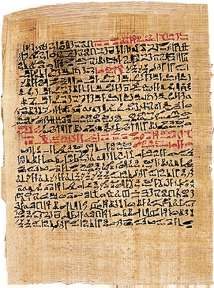
The ancient Egyptians encountered a troublesome everyday reality: periodically the Nile River flooded the fertile lands. Given this circumstance, it was necessary to establish a system to accurately measure the terrain. This need prompted them to create a measurement technique, land surveying. With it they resolved the delimitation of the surface and, in parallel, they could apply it to urban planning, cartography, the construction of pyramids, etc.
Surveying as delimitation is the foundation of geometry. This knowledge had a practical and theoretical dimension and was incorporated by the Romans to establish control over the conquered lands and to plan their public projects (for example, the construction of the road network throughout the Empire).
Throughout history, land or sea measurement procedures have not stopped evolving. Currently we have GPS as a highly accurate instrument, but this advance has been reached because before there were others: the compass, the altimeter, the tape measure or the sextant.