 A Map is a geographic representation of the planet earth or a region on a flat surface, although, it deserves to be mentioned, that there are also those represented in spherical surfaces, such is the case of earth globes.
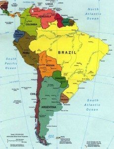
Map that represents the political, administrative divisions and even the communication routes of a territory
There is a varied number of maps, among which stands out the political map, which is that map, generally made on a small scale and which represents both the political and administrative divisions that a territory presents and that then, with the mission of differentiating them from each other, is that they appear distinguished from the use of different colors.
Thus, the political map makes it easier for us to distinguish between localities, provinces, cities , which correspond to a country.
Likewise, it is common that in addition to the aforementioned administrative political divisions this type of map has differentiated the train tracks and routes that are part of the territory in question.
How is the representation carried out?
Each country is distinguished with a color on the political map and the lines that comprise its territory are the political borders.
This outline that will be formed will allow us to appreciate and know the limits of the sovereignty of this or that country and the relations with neighboring countries.
There is also the so-called administrative division, into provinces, departments, autonomous cities, as appropriate.
The most relevant cities are identified with a point, while the capital is highlighted with a point, but larger in size.
They also contain supplementary information, as we have already pointed out, roads, ports, among other means of communication and connection that are present throughout the entire territory and that precisely allow its inhabitants and visitors to connect with the various places.
Regarding geographic information, it can be seen in this type of map, but it has a rather secondary presence.
Meanwhile, it will be from the metric properties arranged on the political map that measurements can be drawn and geographic distances calculated with great precision.
Objectives: educate and inform the situation of a country
Regarding the primary objective of this type of map is to train and educate students in school, at the request of the subjects of history and geography, where the subject in question is especially addressed.
These maps allow you to easily identify places, since the visual possibility is more didactic than a text in a manual.
We must know that the geography of a country can be a determining factor in the political situation of a country and also its development and progress.
And by case is that these maps are very elementary and precious tools for the aforementioned areas of knowledge, history and geography, and also for many others.
Just by looking at a political map in detail, it is possible to understand the geopolitical situation of a country, that is, the way in which it is projected to the world.
We return to the point, that the history of the countries will be conditioned by their geographical locations and by the political borders they have.
It is also very important and a way to achieve a global understanding of a country, the comparison that can be made with a political map and with other maps, such as topographic, geological, climatic, economic, among others.
The map has been an issue that has revealed to man since ancient times, since the desire of human beings to know the world made them work hard to achieve the highest reliability of them, today, without a doubt, it is they stand as an inexhaustible and very important source of information that has been achieved through time and scientific and technological advances, placed at its service, an impressive evolution with respect to those first manifestations that involved traces in the sand or in the snow.
Cartography: discipline that studies and develops maps
Cartography is the name of the discipline that deals exclusively with both the study and the elaboration of geographic maps and cartographer It is the term that designates the individual who is professionally dedicated to cartography, that is, to the realization of maps.